Carlingwood
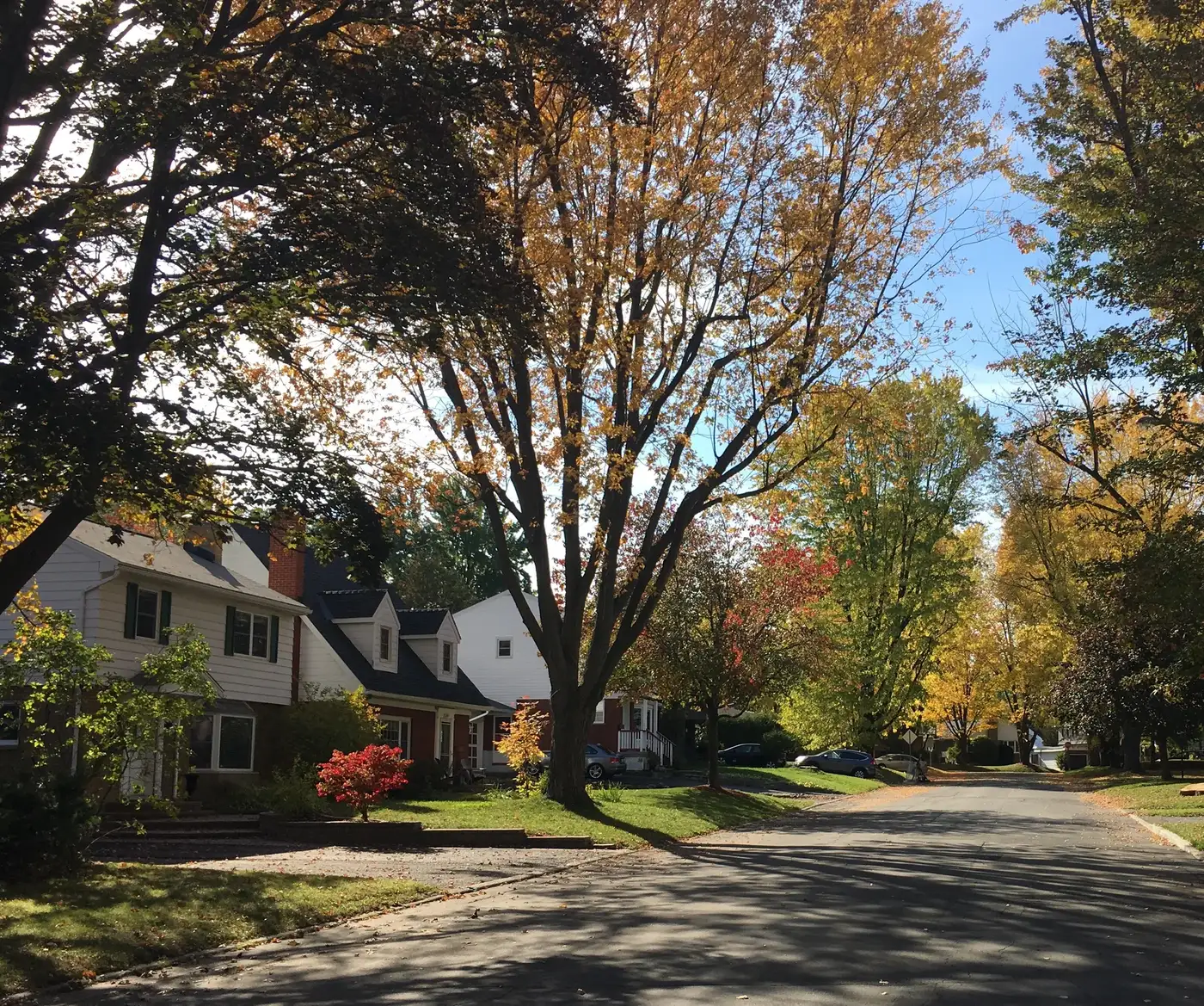
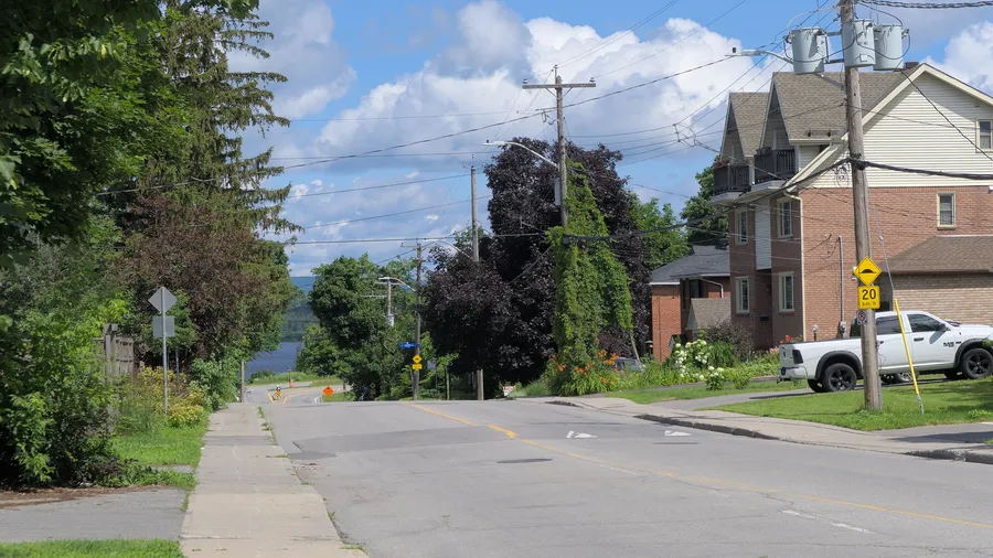
Mid-century streets built around Carlingwood Shopping Centre, with schools, parks and the library all within walking distance.
* Ottawa Neighbourhood Study figures for its “Laurentian (Carlingwood, Highland Park, McKellar Park)” area, which is larger than Carlingwood alone.
Carlingwood is an established west-end Ottawa neighbourhood in Bay Ward, roughly bounded by Richmond Road, Sherbourne Road, Carling Avenue and Woodroffe Avenue. From the Carlingwood centre it is about 8 minutes to Woodroffe Avenue Public School (OCDSB, grades K–8), 6 to Loblaws and 13 to the future Sherbourne O-Train station (under construction, opening listed for 2027) on foot (OSRM estimates). The Ottawa Neighbourhood Study's 'Laurentian (Carlingwood, Highland Park, McKellar Park)' area had 11,420 residents in the 2021 census.
Updated · Facts on this page link to their sources
From the Carlingwood centre
Walking and driving times to the nearest schools, O-Train stations and grocery stores.
| To | Nearest | Walk | Route | Drive |
|---|---|---|---|---|
| Elementary school | Woodroffe Avenue Public School (OCDSB, grades K–8) | 8 min | 610 m | 2 min |
| Elementary school | Our Lady Of Fatima School (OCSB, grades JK–6) | 9 min | 650 m | 2 min |
| Secondary school | Notre Dame High School (OCSB, grades 7–12) | 20 min | 1.5 km | 4 min |
| Secondary school | Nepean High School (OCDSB, grades 9–12) | 21 min | 1.6 km | 5 min |
| O-Train (open) | Tunney's Pasture | 65 min | 4.9 km | 9 min |
| O-Train (under construction) | Sherbourne (opening listed for 2027, provisional) | 13 min | 960 m | 2 min |
| Grocery store | Loblaws | 6 min | 460 m | 1 min |
| Grocery store | Produce Depot | 15 min | 1.1 km | 3 min |
Estimates from OSRM on OpenStreetMap data: walking at about 5 km/h on streets and paths (no waits at crossings), driving in free-flowing traffic. Calculated 2026-10-30. Map data © OpenStreetMap contributors (ODbL).
About Carlingwood
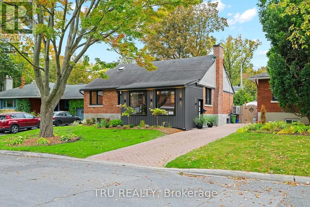
Carlingwood is an established west-end Ottawa neighbourhood in Bay Ward, roughly bounded by Richmond Road, Sherbourne Road, Carling Avenue and Woodroffe Avenue. It grew up around Carlingwood Shopping Centre, which opened in 1956, with the surrounding streets built out later that decade; the adjoining Glabar Park area was built mainly as single-family homes between the 1940s and 1960s. Today it pairs quiet mid-century residential streets with everyday conveniences in walking distance: elementary schools, neighbourhood parks with rinks and wading pools, a public library branch and the mall. It suits families who want walkable schools and parks, and downsizers looking for one-level bungalow living close to shopping, healthcare and future O-Train service, with Westboro Village and the Ottawa River about 2 km away.
Boundaries
Roughly bounded by Richmond Road to the north, Sherbourne Road to the east, Carling Avenue to the south and Woodroffe Avenue to the west (Wikipedia). McKellar Park lies across Sherbourne to the north-east and Woodroffe North across Richmond to the north-west. ONS includes Carlingwood in its 'Laurentian' area. en.wikipedia.org ons-sqo.ca
Homes
Mainly late-1950s single-family streets built after the mall opened in 1956, plus apartment buildings: Somerset Towers and the Saville Apartments (early 1960s) and Bromley Square (1972). ONS includes Carlingwood in its 'Laurentian' area, which was 47.5% single-detached in the 2021 census. en.wikipedia.org ons-sqo.ca
- Steps to Our Lady of Fatima Catholic elementary (~0.15 km) and Woodroffe Avenue Public School (~0.4 km) - confirm boundaries with each board
- Woodroffe Park around the corner (~0.2 km) with a community ice rink and city wading pool
- Walk to Carlingwood Shopping Centre (~0.5 km): about 100 stores, Loblaws, and Canadian Tire's largest Canadian store
- Carlingwood library branch ~0.5 km away (Canada's first mall library opened at Carlingwood in 1957)
- Future O-Train Sherbourne station ~0.3 km away on the Line 1 west extension (opening targeted for 2027; timing subject to flood repairs)
- About 2 km to Westboro Beach, the riverfront pathways and Westboro Village shops and cafes
- About 10 min drive to the Ottawa Hospital Civic Campus and 14 min to Parliament Hill (OSRM estimates, no traffic)
- Established mid-century neighbourhood - the area grew around Carlingwood Shopping Centre after it opened in 1956
Distances in these highlights are straight-line from 2110 Honeywell Ave.
Community
How Carlingwood came to be
- 1956
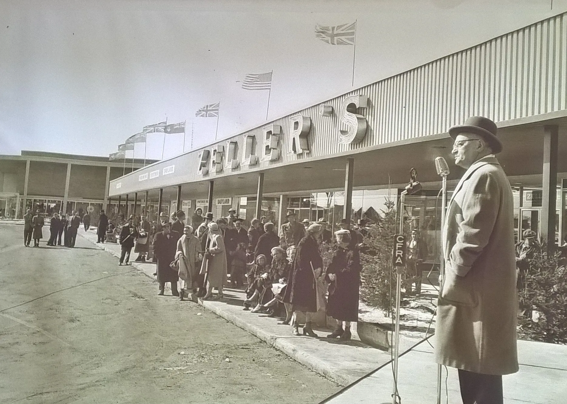
Carlingwood Shopping Centre was built in 1956 at the corner of Carling and Woodroffe; the surrounding neighbourhood was built later in that decade. en.wikipedia.org
- 1957
The Carlingwood library branch opened at the mall in 1957 as Canada's first mall library (per the earlier property research). about.biblioottawalibrary.ca
- 1960s-1972
Somerset Towers and the Saville Apartments (then Saville Terrace) were built in the early 1960s, and Bromley Square in 1972. en.wikipedia.org
- 2020s
The O-Train Line 1 west extension runs in a cut-and-cover tunnel under the Byron Linear Tramway Park on the neighbourhood's north side, with Sherbourne and New Orchard stations. en.wikipedia.org
Around Carlingwood
Walking rings at 5, 10 and 15 minutes from the neighbourhood centre.
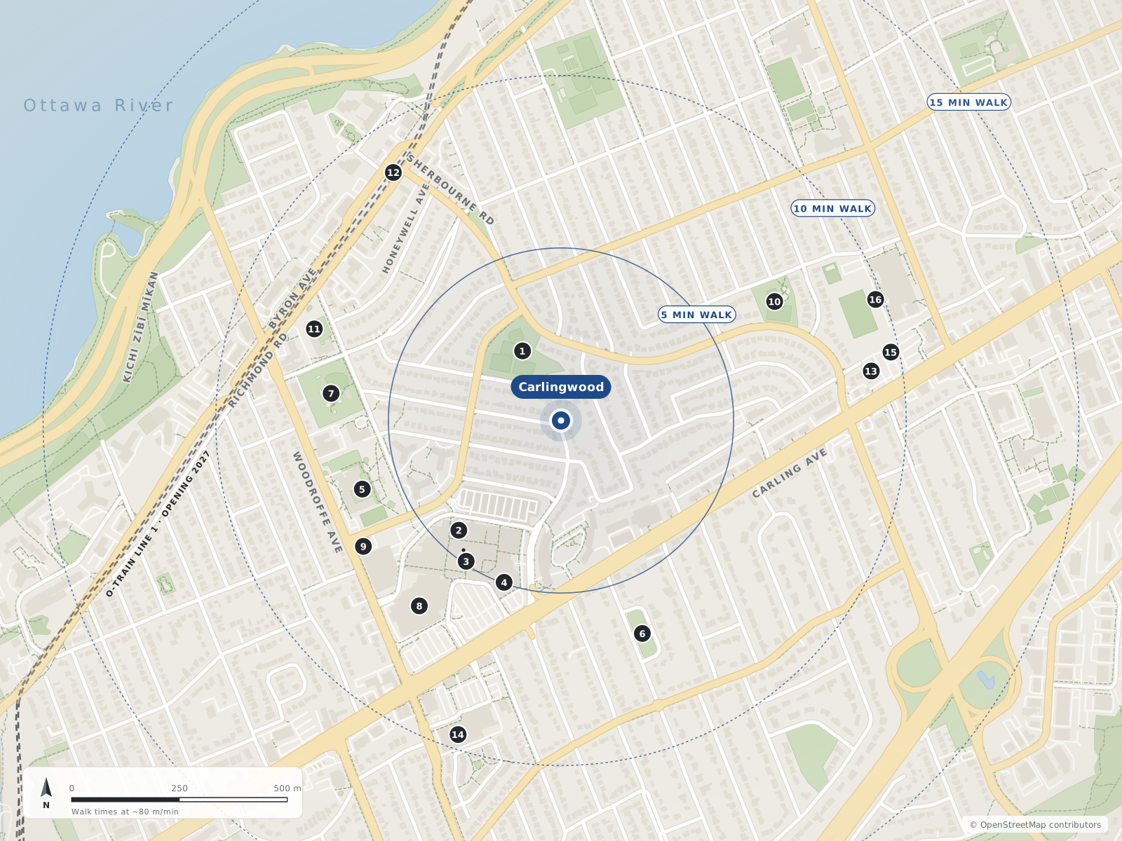
- 1Westwood Park190 m
- 2Coles350 m
- 3Carlingwood Shopping Centre380 m
- 4Loblaws400 m
- 5Woodroffe Avenue PS490 m
- 6Glabar Park530 m
- 7Woodroffe Park540 m
- 8Canadian Tire540 m
- 9Ottawa Public Library - Carlingwood Branch540 m
- 10David Shentow Park570 m
- 11Our Lady Of Fatima School610 m
- 12Sherbourne700 m
- 13Produce Depot730 m
- 14Trailhead Paddle Shack770 m
- 15Thyme & Again Kitchen & Food Shop780 m
- 16Notre Dame HS780 m
Schools
9 nearbyWoodroffe Avenue Public School
OCDSBGrades K–8235 Woodroffe Avenueopenstreetmap.org woodroffeaveps.ocdsb.ca
490 m6 min walkOur Lady Of Fatima School
OCSBGrades JK–62135 Knightsbridge Roadopenstreetmap.org olf.ocsb.ca
610 m8 min walkNotre Dame High School
OCSBGrades 7–12710 Broadview Avenueopenstreetmap.org ndh.ocsb.ca ndh.ocsb.ca
780 m10 min walkBroadview Public School
OCDSBGrades JK–8590 Broadview Avenueopenstreetmap.org broadviewps.ocdsb.ca
950 m12 min walkNepean High School
OCDSBGrades 9–12574 Broadview Avenueopenstreetmap.org nepeanhs.ocdsb.ca
1.0 km13 min walkEdelweiss Private Academy
Independent31 Nadolny Sachs Privateopenstreetmap.org
1.1 km14 min walkOttawa Jewish Community School
Independent31 Nadolny Sachs Privateopenstreetmap.org
1.1 km14 min walkD. Roy Kennedy Public School
OCDSBGrades JK–8919 Woodroffe Avenueopenstreetmap.org droykennedyps.ocdsb.ca
1.2 km15 min walkCharlotte-Lemieux Public Elementary School
CEPEO2093 Bel-Air Driveopenstreetmap.org charlotte-lemieux.cepeo.on.ca
1.5 km18 min walk
Straight-line distances from the Carlingwood centre. Living near a school does not guarantee a place: confirm the designated school for an address with each board. All schools and board locators.
Parks & places
10 nearbyWestwood Park
City of Ottawa neighbourhood park on Saville Row (dogs allowed per OSM).
2000 Saville Rowopenstreetmap.org
190 m2 min walkGlabar Park
City park on Hare Avenue in Glabar Park (dogs allowed per OSM).
845 Hare Avenueopenstreetmap.org
530 m7 min walkWoodroffe Park
City park with a fieldhouse, a supervised outdoor rink and a wading pool (per OSM/City data).
180 Lockhart Avenueopenstreetmap.org openstreetmap.org openstreetmap.org
540 m7 min walkOttawa Public Library - Carlingwood Branch
Three-storey Ottawa Public Library branch with a children's department, meeting room and Friends of OPL used book store; reopened Sept 14, 2026 after Canada Day 2026 storm damage (some programs/children's collection initially limited).
281 Woodroffe Avenueopenstreetmap.org about.biblioottawalibrary.ca forms.biblioottawalibrary.ca
540 m7 min walkDavid Shentow Park
City park on Tillbury Avenue West (leashed dogs per OSM).
590 Tillbury Avenue Westopenstreetmap.org
570 m7 min walkMcKellar Park
City park with the McKellar Park Fieldhouse (programs run by the Dovercourt Recreation Association), a supervised double-surface outdoor rink and a wading pool.
539 Wavell Avenueopenstreetmap.org openstreetmap.org openstreetmap.org
800 m10 min walkNew Orchard Park
City park on New Orchard Avenue.
243 New Orchard Avenueopenstreetmap.org
990 m12 min walkByron Linear Tramway Park
Linear City park along the former Byron streetcar corridor; it hosts the Westboro Farmers' Market on Saturdays (May 16 – Oct 31, 2026), and the underground Sherbourne and New Orchard O-Train stations are being built along its western end.
579 Byron Avenueopenstreetmap.org ottawafarmersmarket.ca en.wikipedia.org
1.0 km13 min walkAmbleside Park
Park on Ambleside Drive (dogs allowed per OSM).
1083 Ambleside Driveopenstreetmap.org
1.2 km15 min walkWestboro Kiwanis Park
City park beside the Dovercourt Recreation Centre with a supervised outdoor rink in winter and the Westboro wading pool in summer (per OSM/City data).
411 Dovercourt Avenueopenstreetmap.org openstreetmap.org openstreetmap.org
1.3 km16 min walk
Shops & dining
7 nearbyColes
Coles bookstore inside Carlingwood Shopping Centre.
2121 Carling Avenueopenstreetmap.org
350 m4 min walkCarlingwood Shopping Centre
Enclosed mall opened in 1956 with about 100 stores; anchors include Loblaws and a Canadian Tire flagship (opened 2022).
2121 Carling Avenueopenstreetmap.org en.wikipedia.org
380 m5 min walkLoblaws
Full-service Loblaws supermarket at Carlingwood.
2085 Carling Avenueopenstreetmap.org
400 m5 min walkCanadian Tire
Canadian Tire store at Carlingwood (hardware, home and sporting goods), opened 2022.
2165 Carling Avenueopenstreetmap.org en.wikipedia.org
540 m7 min walkProduce Depot
Greengrocer (produce store) on Carling Avenue.
1855 Carling Avenueopenstreetmap.org
730 m9 min walkTrailhead Paddle Shack
Outdoor/paddling shop on Carling Avenue.
2148 Carling Avenueopenstreetmap.org
770 m10 min walkThyme & Again Kitchen & Food Shop
Kitchen and prepared-food shop on Carling Avenue.
1845 Carling Avenueopenstreetmap.org
780 m10 min walk
Getting around
TransitWoodroffe Avenue bus corridor
North–south street past the Carlingwood library; OSM bus route relations include 51, 87 and 153. Confirm on octranspo.com.
openopenstreetmap.org overpass-api.de
570 m7 min walkCarling Avenue bus corridor
Arterial past Carlingwood Shopping Centre; OSM bus route relations on Carling Avenue in the area include 51, 81, 85, 87, 153 and shopper routes 301/303/305. Confirm on octranspo.com.
openopenstreetmap.org overpass-api.de
580 m7 min walkSherbourne
Future underground O-Train station along the Byron Linear Tramway Park / Richmond Road corridor. Not open as of Oct 2026. OC Transpo (Mar 12, 2026) expected handover to the City in Q2 2027 and passenger service in Q3 2027; Canada Day 2026 flooding damaged parts of the extension between New Orchard and Moodie and OC Transpo has said it may open the extension in parts (CTV, Aug 5, 2026).
under constructionopenstreetmap.org octranspo.com en.wikipedia.org
700 m9 min walkNew Orchard
Future underground O-Train station near New Orchard Avenue; OC Transpo reported faregates installed and interior finishing nearing completion in 2025. Not open as of Oct 2026. OC Transpo (Mar 12, 2026) expected handover to the City in Q2 2027 and passenger service in Q3 2027; Canada Day 2026 flooding damaged parts of the extension between New Orchard and Moodie and OC Transpo has said it may open the extension in parts (CTV, Aug 5, 2026).
under constructionopenstreetmap.org octranspo.com en.wikipedia.org
900 m11 min walkBus (OC Transpo)
OpenStreetMap route data shows routes 11, 51, 87 and 153 serving stops within ~450 m (Richmond Rd, Woodroffe Ave, Saville Row, Dovercourt/Sherbourne). Wikipedia lists 51, 11, 85 and 87 for Carlingwood. Route numbers change - confirm on octranspo.com before publishing.
O-Train (Line 1 west extension)
Sherbourne station (underground, ~0.3 km) and New Orchard station (~0.6 km) are under construction; Lincoln Fields (~1.6 km) will be the junction where Lines 1 and 3 split. Opening is listed for 2027. CTV (Mar 12, 2026) reported the west extension launch delayed to summer 2027; Canada Day 2026 flooding damaged parts of the extension between New Orchard and Moodie, and OC Transpo is considering a partial opening (CTV, Aug 5, 2026). Not yet open as of Oct 2026.
Drive - downtown
Parliament Hill: ~10.0 km by road, ~14 min (OSRM routing estimate, free-flow; rush hour longer). Tunney's Pasture: ~5.4 km, ~9 min.
Drive - hospitals
Ottawa Hospital Civic Campus ~5.4 km / ~10 min; Queensway Carleton Hospital ~6.1 km / ~9 min (OSRM estimates).
Neighbouring areas
Quick answers
Short answers first; each links to the full answer and its sources.
Where is Carlingwood in Ottawa?
Carlingwood is a west-end Ottawa neighbourhood roughly bounded by Richmond Road, Sherbourne Road, Carling Avenue and Woodroffe Avenue. It grew up around Carlingwood Shopping Centre, which opened in 1956.
As of 2026-10-30 · en.wikipedia.org ons-sqo.ca
Is Carlingwood good for families?
From the Carlingwood centre, Woodroffe Avenue Public School (K–8) is about an 8-minute walk and Our Lady of Fatima School (JK–6) about 9 minutes. Woodroffe Park has a rink and wading pool, Loblaws is about 6 minutes on foot, and the Carlingwood library has a children's department.
As of 2026-10-30 · westboro.homes openstreetmap.org
Which City of Ottawa ward is Westboro in?
Westboro, Westboro Beach and Highland Park are in Kitchissippi Ward (Ward 15). McKellar Park, Carlingwood and Woodroffe North are in Bay Ward (Ward 7), and the line between the two wards runs along Denbury Avenue.
As of 2026-10 · kitchissippi.com cbc.ca
Is Carlingwood a good place to retire or downsize?
Carlingwood's streets are mainly late-1950s single-family homes around Carlingwood Shopping Centre. Loblaws is about a 6-minute walk from the centre, the mall has a Rexall pharmacy, the library is about 0.5 km away, and Queensway Carleton Hospital and the Civic Campus are 9 and 10 minutes by car.
As of 2026-10-30 · westboro.homes openstreetmap.org
What schools are closest to Carlingwood, Ottawa?
From the Carlingwood centre, Woodroffe Avenue Public School (OCDSB, K–8) is about an 8-minute walk and Our Lady of Fatima School (OCSB, JK–6) about 9 minutes. The nearest high schools are Notre Dame (OCSB, grades 7–12) at about 20 minutes and Nepean (OCDSB, grades 9–12) at about 21 minutes.
As of 2026-10-30 · westboro.homes openstreetmap.org
What is the difference between Westboro and Carlingwood?
Westboro is the older village around Richmond Road, with most houses built between 1900 and 1960 and many newer condos, while Carlingwood is mostly late-1950s single-family streets built around Carlingwood Shopping Centre. In the 2021 census, the ONS 'Westboro' area was 21.9% single-detached houses and 53.6% renters, compared with 47.5% and 41.6% in the 'Laurentian' area that includes Carlingwood.
As of 2026-10-30 · en.wikipedia.org en.wikipedia.org